What geology hides, fantastic field trip through the Puebla Valley, Mexico

Good morning everyone, last Thursday, I had a field trip through the Puebla valley, which is located on the territorial limits of Mexico and Morelos. We were studying the andesite outcrops in the region, where the mythical Popocatépetl volcano, also known as Don Goyo, is located. As a geologist by profession, it is interesting to share this, but even more so as a photography lover. Here I show you some aerial images taken during the march.

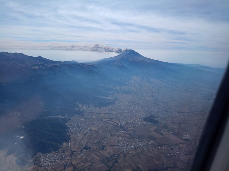
Photograph taken during the flight over the State of Puebla.
Popocatépetl ' Smoking Mountain', also known as Don Goyo , is an active volcano located in Mexico . It has an altitude of 5400 meters above sea level. It is located in the territorial limits of the states of Mexico , Morelos and Puebla . It is located about 72 km southeast of Mexico City , 43 km from Puebla, 63 km from Cuernavaca , and 53 km from Tlaxcala.
It has a symmetrical conical shape, and is linked on the northern part to Iztaccíhuatl by a mountain pass known as Paso de Cortés . The volcano had perennial glaciers near the mouth of the cone, at the top of the mountain. It is the second highest volcano in Mexico , only after Citlaltépetl , at 5,636 m.

Photograph taken at the volcano Popocatepetl smoking.
Aerial view of the state of Puebla, area where the volcano is located.
Popocatépetl is one of the most active volcanoes in the country and is located in the territorial limits of the entities of Morelos, Puebla and the State of Mexico, however, it is close to Mexico City and Tlaxcala .
Its name, coming from the Nahuatl language , composed of popōca "smoke" and tepētl "mountain, hill", together means "smoking mountain", due to its constant activity since pre-Hispanic times .
Popocatépetl is a stratovolcano located in Mexico. It is located on the borders of the Mexican states of Puebla, Morelos and the State of Mexico, being the southernmost of the large volcanoes of the so-called Sierra Nevada. It extends east of the Valley of Mexico, and is the only asset among those surrounding the country's capital. Paleomagnetic studies that have been done on it indicate that it is approximately 730,000 years old. Its height is 5500 m above sea level. n. m., is conical in shape, has a diameter of 25 km at its base and the summit is the elliptical cut of a cone and has a northeast-southwest orientation. The distance between the walls of its crater varies between 660 and 840 m.

Image captured of most of the valley of Puebla with the illustrious Popocatepetl Volcano in the distance.
Only when looking at it from the north side does one notice that the current cone was formed on an older volcanic mass, about 3,800 meters high. Indeed, at 5000 meters the symmetry is destroyed by the Fraile peak, a slight protuberance that protrudes from the northwest flank and is a vestige of the Nexpayantla , an ancient stratovolcano, buried under the alternation of waves of lava and layers of pyroclasts that form the current cone.
The crater is a deep hole with an elliptical section whose axes measure 600 and 400 meters and whose highest point is to the northwest.

Aerial image capturing the Puebla valley region and its horizons.
Popocatépetl arose at the point of intersection of the transverse volcanic axis with a secondary fracture oriented to the north-northwest. When erosion had finished destroying the Nexpayantla (of Miocene or Pliocene epic ), the current volcano, which appeared at the beginning of the Pleistocene, maintained a constant activity so intense that despite the altitude, glaciation did not begin until the Würm , when it was formed. at the summit a blizzard of emissary tongues of ice. Thick layers of pumice from the late Pleistocene show that eruptions continued to be violent until the pre-Archaic era of Mexican archaeology.
Main areas that could be affected by the eruption of the Popocatépelt volcano.
Popocatépetl is known for its high volcanic activity that occurs commonly. Since it was reactivated in 1994 until now, it has presented a series of eruptions, the most violent of which were in 2000, and the early morning of April 18, 2016. Another eruption was on February 16, 2018 after the 7.2 earthquake on the Richter scale that hit Mexico . The volcano expelled a large fumarole of water and ash that reached 700 meters high at 6:24 p.m. local time.
The last recorded eruption was on May 19, 2023.
The volcano is one of the most monitored in the world and is also one of the most dangerous, threatening more than 26 million people.
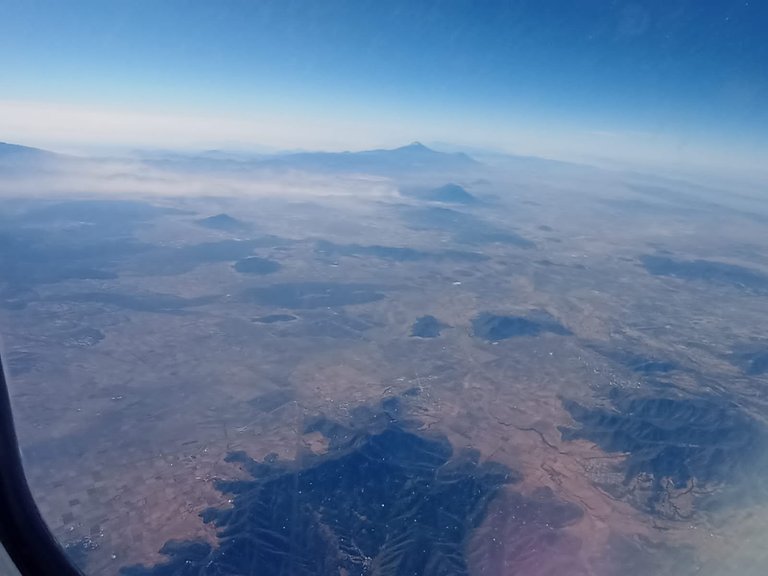
Photograph taken from far away to recognize the height of the volcano and the length of the valley and all the geological structures.
Happy to be able to share this experience with you, my photographs and everything that led me to donate this great event about an outing in the field as a geologist, thank you very much and have a nice day.
All published photos are my property taken with my Sony Alpha 7 II camera.
Congratulations @charlemio! You have completed the following achievement on the Hive blockchain And have been rewarded with New badge(s)
Your next payout target is 50 HP.
The unit is Hive Power equivalent because post and comment rewards can be split into HP and HBD
You can view your badges on your board and compare yourself to others in the Ranking
If you no longer want to receive notifications, reply to this comment with the word
STOPCheck out our last posts:
Que fotos más bonitas ☺️