Earth Secrets: Water Beats Rock Continued

Secretos de la Tierra: El agua vence a la roca Continuación
¡Hola, hola, Hivernautas! Continuamos con la serie Los secretos de la Tierra. En el anterior artículo hablamos sobre el proceso de erosión que ocurre en las rocas a raíz del choque con el agua, formaciones como: costas, glaciares, ríos, cataratas, ocurren en el transcurso del tiempo, como parte de este proceso.
En el proceso fenómeno geomorfológico se produce lo que se conoce como meandros. En los meandros el río va lamiendo suave, pero impecablemente, la orilla externa de la curva, mientras deposita parte de los materiales que acarrea en la otra. Así el río va desplazando lateralmente su curso, pero como esto ocurre en todas las curvas de los meandros, el río acaba por conseguir limar el terreno lo suficiente como para poder avanzar en línea recta, abandonando como cauce seco el antiguo meandro.
Los meandros son una característica común en muchos ríos de todo el mundo y a menudo son una vista impresionante y hermosa para los observadores de la naturaleza. Sin embargo, la actividad humana, como la construcción de presas y la urbanización, puede tener un impacto significativo en los meandros y en la ecología de los ríos en general.
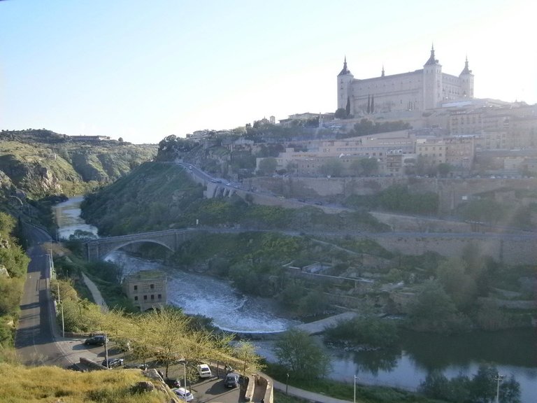
Río Tajo en España posee proceso geomorfológico por sus características. Créditos: Imagen libre www.flickr.com
Al llegar a las proximidades del mar hay dos posibilidades para un río. Si discurre por un valle entre montañas, seguirá directamente hasta que encuentre el mar y vierta en él sus aguas. Pero si se encuentra con una amplia llanura con desniveles prácticamente inexistentes, el río se divide en una ramificación más o menos complicada de cauces menores. Al mismo tiempo, su velocidad se hace mínima y sin fuerza que lo arrastre. Los productos de la erosión se van depositando y originan unos terrenos sedimentarios que hacen que la tierra avance hacia el mar. Cuando ocurre un fenómeno de este tipo se dice que el río ha formado un Delta.

El Nilo, uno de ríos más extensos del mundo, un ejemplo de formaciones Delta. Créditos: Imagen libre pixabay.com
Pero no siempre las aguas superficiales forman ríos y lagos. En ocasiones, en terrenos arenosos que tienen debajo una capa impermeable que no deja pasar el agua, se forman pantanos.
A veces, damos el nombre de pantano al lago que se forma a causa de una presa artificial construida por los humanos, pero está mal dicho, esto no es un pantano, sino un embalse. Los embalses son una muestra de la actividad geológica de la humanidad, los pantanos son accidentes de la naturaleza. Las zonas pantanosas, tan interesantes para el biólogo, son centro de algunas actividades geológicas. La más interesante de ellas es quizás la carbonización de resto de vegetales, como puede observarse en las turberas actuales.
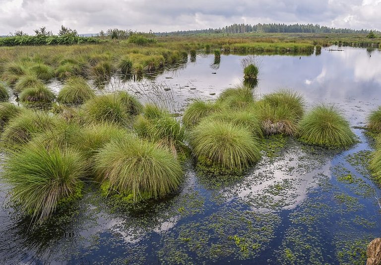
Los pantanos son importantes para el ecosistema y la biodiversidad. Créditos: Imagen libre pxfuel.com
Cuando se producen lluvias muy intensas, el río crece considerablemente de caudal. Su ímpetu erosivo es entonces enorme y puede observarse a simple vista por el hecho de que las aguas bajan turbias y oscuras, debido a la gran cantidad de materiales que arrastra. En ocasiones las crecidas son tan grandes que el río se desborda porque su cauce le resulta insuficiente, provocando inundaciones. Tomando precauciones contra posibles crecidas, en algunos ríos se han efectuado obras de encauzamiento para evitar futuras inundaciones. Las inundaciones son peligrosas porque producen pérdidas, a veces considerables, en bienes y en vidas humanas.
No todas las aguas continentales son superficiales. La Tierra es pródiga en aguas subterráneas, y este hecho se conoce desde hace mucho. El agua de lluvia corre por la superficie, pero también se filtra por el suelo hasta que encuentre una capa de terreno impermeable y entonces forma bolsas o mantos de agua.

vista aérea de la inundación causada por el río Cachoeira Brasil. Créditos: Leonardo Benassatto elpais.com
Los pozos que se perforan para la obtención de agua no son más que accesos a estas capas acuíferas. Existen una variedad muy importante de ellos que son los pozos artesianos.
Los pozos artesianos perforan los terrenos hasta llegar a un manto de agua encerrado entre dos capas de terreno impermeable. Estos mantos de agua suelen ser bastantes largos y no están siempre al mismo nivel. Como cuando se busca agua se perfora en hondonadas, normalmente se atraviesa el manto de agua en uno de sus puntos más bajos. Entonces el agua, al sentirse libre, tiende a ascender para igualar su nivel al de la capa superior del manto, por lo que en muchas ocasiones origina un auténtico surtidor.
Los géiseres son unos surtidores intermitentes de agua caliente que brotan de la tierra. Un géiser brota cuando una fisura en el terreno sirve de válvula de escape a una bolsa de agua recalentada por alguna afloración del manto. Cada vez que hay superficie de presión, el agua hirviente brota a la superficie.
Otro aspecto muy interesante de las aguas subterráneas es su acción erosiva, que se traduce en cuevas de singular belleza, sobre todo en terrenos calcáreos.
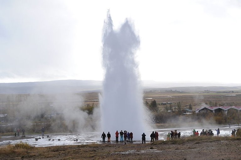
Géiser Strokkur, se encuentra en el Valle de los Géiseres Islandia. Créditos: Imagen libre commons.wikimedia.org
En resumen, el agua posee un enorme poder geológico, en ocasiones hasta destructivo, pero también fundamental para vida en la tierra.
¡Hasta la próxima, Hivernautas!
IMAGENES
Imagen 1: Fuente
Imagen 2: Fuente
Imagen 3: Fuente
Imagen 4: Fuente
Imagen 5: Fuente
REFERENCIA
- https://www.geoenciclopedia.com/meandro-que-es-caracteristicas-y-como-se-forma-587.html
- https://education.nationalgeographic.org/resource/delta/
- https://www.renovablesverdes.com/pantanos-caracteristicas-e-importancia/
- https://www.ecologiaverde.com/causas-y-consecuencias-de-las-inundaciones-1282.html
- https://humanidades.com/inundaciones/
- https://www.fundacionaquae.org/wiki/geiseres-erupciones-de-agua-subterranea/
English Edition
Earth Secrets: Water Beats Rock Continued
Hello, hello, Winternauts! We continue with the series The secrets of the Earth. In the previous article we talked about the erosion process that occurs in the rocks as a result of the collision with the water, formations such as: coasts, glaciers, rivers, waterfalls, occur over time, as part of this process.
In the process geomorphological phenomenon occurs what is known as meanders. In meanders, the river gently but impeccably laps the outer bank of the curve, while depositing part of the materials it carries on the other. Thus the river moves its course laterally, but as this occurs in all the curves of the meanders, the river ends up managing to smooth the terrain enough to be able to advance in a straight line, leaving the old meander as a dry bed.
Meanders are a common feature in many rivers around the world and are often a stunningly beautiful sight for nature observers. However, human activity, such as damming and urbanization, can have a significant impact on meandering and river ecology in general.
The Tagus River in Spain has a geomorphological process due to its characteristics. Credits: Free Image www.flickr.com
Upon reaching the vicinity of the sea there are two possibilities for a river. If it runs through a valley between mountains, it will continue directly until it finds the sea and pours its waters into it. But if it comes across a wide plain with practically non-existent slopes, the river divides into a more or less complicated ramification of minor channels. At the same time, his speed becomes minimal and without force to drag him. The products of erosion are deposited and originate sedimentary grounds that make the land move towards the sea. When a phenomenon of this type occurs, it is said that the river has formed a Delta.
The Nile, one of the world's longest rivers, an example of Delta formations. Credits: Free image pixabay.com
But not always surface waters form rivers and lakes. Sometimes, in sandy terrains that have an impermeable layer underneath that does not let water through, swamps are formed.
Sometimes, we give the name of swamp to the lake that is formed by an artificial dam built by humans, but it is wrong, this is not a swamp, but a reservoir. The reservoirs are a sample of the geological activity of humanity, the swamps are accidents of nature. The swampy areas, so interesting for the biologist, are the center of some geological activities. The most interesting of them is perhaps the carbonization of the rest of the plants, as can be observed in the current peat bogs.
Wetlands are important for the ecosystem and biodiversity. Credits: Free Image pxfuel.com
When very intense rains occur, the river increases considerably in flow. Its erosive force is then enormous and can be seen with the naked eye due to the fact that the waters come down cloudy and dark, due to the large amount of materials that it drags. Sometimes the floods are so great that the river overflows because its channel is insufficient, causing flooding. Taking precautions against possible floods, channeling works have been carried out in some rivers to prevent future flooding. Floods are dangerous because they produce losses, sometimes considerable, in property and in human lives.
Not all inland waters are superficial. The Earth is abundant in groundwater, and this fact has been known for a long time. Rainwater runs along the surface, but it also seeps through the ground until it finds a layer of impermeable soil and then forms pockets or sheets of water.
Aerial view of the flood caused by the river Cachoeira Brazil. Credits: Leonardo Benassatto elpais.com
The wells that are drilled to obtain water are nothing more than accesses to these aquifer layers. There is a very important variety of them that are artesian wells.
Artesian wells drill the land until they reach a layer of water enclosed between two layers of impermeable soil. These sheets of water are usually quite long and are not always at the same level. Since when looking for water you drill in hollows, you normally cross the water table at one of its lowest points. So the water, feeling free, tends to rise to equalize its level to that of the upper layer of the mantle, which is why on many occasions it originates a real fountain.
Geysers are intermittent fountains of hot water that spring from the earth. A geyser erupts when a fissure in the ground serves as an escape valve for a bag of water heated by an outcropping of the mantle. Every time there is a pressure surface, boiling water bubbles up to the surface.
Another very interesting aspect of groundwater is its erosive action, which results in caves of singular beauty, especially in calcareous terrain.
Strokkur Geyser, is located in the Valley of Geysers Iceland. Credits: Image free commons.wikimedia.org
In short, water has enormous geological power, sometimes even destructive, but also essential for life on earth.
Until next time, Hivernauts!
IMAGES
Image 1: Fuente
Image 2: Fuente
Image 3: Fuente
Image 4: Fuente
Image 5: Fuente
REFERENCE
- https://www.geoenciclopedia.com/meandro-que-es-caracteristicas-y-como-se-forma-587.html
- https://education.nationalgeographic.org/resource/delta/
- https://www.renovablesverdes.com/pantanos-caracteristicas-e-importancia/
- https://www.ecologiaverde.com/causas-y-consecuencias-de-las-inundaciones-1282.html
- https://humanidades.com/inundaciones/
- https://www.fundacionaquae.org/wiki/geiseres-erupciones-de-agua-subterranea/
Congratulations @jrevilla! You have completed the following achievement on the Hive blockchain And have been rewarded with New badge(s)
Your next target is to reach 15000 upvotes.
You can view your badges on your board and compare yourself to others in the Ranking
If you no longer want to receive notifications, reply to this comment with the word
STOPCheck out our last posts:
Support the HiveBuzz project. Vote for our proposal!
Thanks for your contribution to the STEMsocial community. Feel free to join us on discord to get to know the rest of us!
Please consider delegating to the @stemsocial account (85% of the curation rewards are returned).
You may also include @stemsocial as a beneficiary of the rewards of this post to get a stronger support.